Technically, fog is cloud at ground level. That is true, but it is not very useful. It does not explain why fog appears in a valley but not on the hillside directly above it, or why coastal fog can persist for a week when inland fog clears by mid-morning, or why some fog is remarkably dense and some barely reduces visibility at all. The definition hides the mechanisms, and the mechanisms are what matter.
What fog has in common with all cloud
All cloud and all fog consists of tiny water droplets or ice crystals suspended in air. For water vapour to condense into those droplets, two things need to happen: the air needs to be at or close to saturation, and there need to be small particles — dust, sea salt, combustion products — for the water to condense onto. These are condensation nuclei, and the air is almost never short of them.
Saturation occurs when the air temperature drops to the dew point — the temperature at which the air can no longer hold all its water vapour in gaseous form. The dew point depends on how much moisture is in the air to begin with. Humid maritime air in Britain often has a dew point within a few degrees of the actual air temperature, which is part of why fog is relatively common here.
The question, then, is what causes the air temperature to drop to the dew point — and this is where the three main fog types diverge.
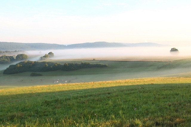
Radiation fog: the valley floor special
Radiation fog forms on clear, calm nights when the ground loses heat rapidly by infrared radiation to the sky. As the ground cools, it cools the air directly above it. If the air cools to its dew point, fog forms — typically in a shallow layer, often only a few metres to a few tens of metres thick, concentrated in low-lying areas.
The topographic concentration happens for a straightforward reason. Cold air is denser than warm air and drains downhill under gravity — a process called katabatic flow. The coldest air accumulates in valley floors and hollows. This is why the hilltop above a fog-filled valley is often clear: the cold air has drained away and the temperature there remains above the dew point.
Radiation fog needs clear skies (cloud would trap the outgoing radiation and prevent the temperature drop), light winds (strong winds mix the air vertically and prevent the surface cooling from concentrating) and moist air. The British autumn is particularly prone to it: long nights, often calm anticyclonic conditions, and air that is still relatively humid from the summer.
It typically clears during the morning as the sun heats the ground and lifts the temperature above the dew point from the surface upward. The fog "burns off" — but what actually happens is that the droplets evaporate rather than burn. The phrase has stuck.
Advection fog: the sea fret
Advection fog forms when warm, moist air moves horizontally over a cooler surface. The surface chills the air from below until it reaches the dew point. Unlike radiation fog, it does not need calm conditions — it can form in moderate winds, which is part of why it is harder to forecast.
The most familiar British example is the sea fret: fog that forms over cold coastal waters and advects inland on a sea breeze. The North Sea coast of England is particularly prone to this in spring and early summer, when the sea surface temperature is still low from winter while the air moving onshore may be relatively warm. A sunny day in Leeds can be genuinely foggy in Whitby, with the same airmass involved in both.
Advection fog can be dense and persistent. Because it is continuously supplied by the movement of air from a source region (typically open sea), it does not simply evaporate once the sun rises. The fog can persist throughout the day if the wind continues to bring in air from the cold surface.
Upslope fog: altitude as a mechanism
Upslope fog is the least familiar of the three main types. It forms when moist air is forced uphill — by terrain — and cools adiabatically as it rises. If it cools to its dew point before reaching the top of the slope, it forms cloud or fog at and above that level.
In Britain, upslope fog is common on upland areas like the Pennines, the Welsh hills and the Scottish Highlands. What looks from below like a dramatic layer of cloud sitting on a hilltop is, from inside it, simply fog with reduced visibility and a tendency to deposit moisture on every horizontal surface — a process called occult deposition, which is considerably more significant for water input to upland ecosystems than is usually appreciated.
A note on freezing fog
Freezing fog deserves a brief mention because it behaves differently from ordinary fog in a way that matters practically. In freezing fog, the air temperature is at or below 0 Celsius, but the droplets remain liquid — supercooled water can remain liquid well below the freezing point if it lacks suitable ice nuclei. When these supercooled droplets contact a surface at or below freezing, they freeze on contact. This produces rime ice: a white, feathery deposit on any exposed surface. On aircraft it is extremely hazardous. On exposed vegetation it produces the spiky white coating that sometimes appears on winter mornings without any obvious precipitation having occurred.